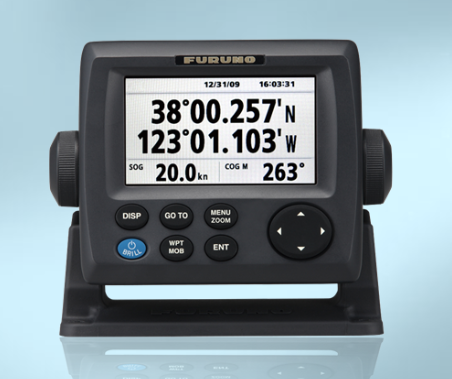
Chartplotter Overview
GPS TRACKING DATA
A chartplotter combines both GPS data and embedded charts to identify the location of the watercraft and calculate its speed and direction. The system also determines the time and distance to reach a desired destination. This may require the connection of a remote GPS sensor located below the boat deck. It operates in real-time, continuously updating the status of the watercraft’s position. Some systems can integrate additional components, such as AIS, sounders, radar antennas, and satellite weather status.
GPS Chartplotter Options:
- Furuno GP33
- Si_Tex SVS-460C
- Furuno GP39
- SI-Tex SVS-760C
--------------
FISHFINDER INTEGRATION
Chartplotters may also display data from other outlets and sensors, such as fishfinders. In fact, the most popular chart-combo display is the chartplotter/fishfinder integration. This is a good option for smaller vessels with limited dashboard room.
Chartplotter/FIshfinder Options
- Raymarine Dragonfly4 Pro
- Lowrance HOOK2 5 SplitShot with Navionics + Maps
- Garmin ECHOMAP Plus 63cv with Transducer
- Simrad G09XSE
--------------
PRELOADED CHARTS
Most chartplotters include preloaded maps and routes for navigation. These routes can be edited at any time during a trip. Each available route will display several waypoints to assist with navigation and help avoid any hazards in the water. Each waypoint along the route is numbered.
Many systems will have the option to purchase additional maps in distant waters if they are needed. In addition, you can upgrade to more detailed and higher resolution maps.